عاجل | الشرق الآسيوي يترقب كابوس «التسونامي».. زلزال مدمر يضرب الفلبين ويهدد ماليزيا – أخبار السعودية
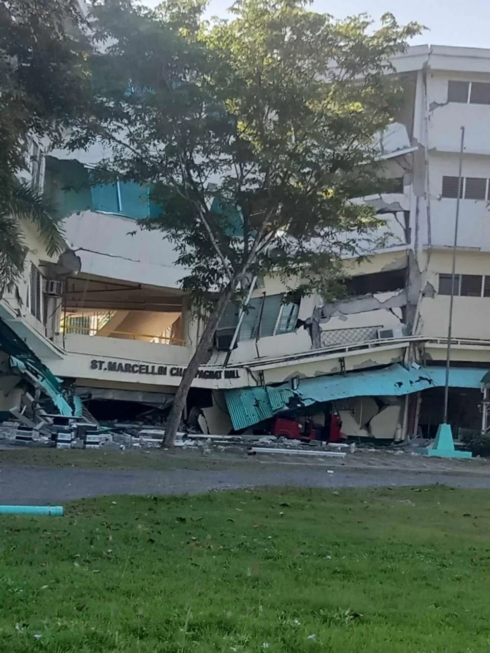
ضرب زلزال مدمر بلغت قوته 7.8 درجة على مقياس ريختر، في وقت مبكر من صباح اليوم الإثنين، منطقة “مينداناو” الواقعة في جنوب الفلبين، وسط مخاوف جادة وتحذيرات رسمية من احتمال تشكل موجات مد بحري عاتية (تسونامي) قد تضرب سواحل المنطقة.
تفاصيل الهزة العنيفة
وأفادت هيئة المسح الجيولوجي الأمريكية بأن الهزة الأرضية العنيفة وقعت في تمام الساعة 7:37 صباحاً بالتوقيت المحلي، وحددت مركز الزلزال على عمق 35 كيلومتراً (22 ميلاً)، وعلى بعد نحو 24.7 كيلومتر غرب-جنوب غرب بلدة “بورياس” الفلبينية.
ورغم قوة الهزة، لم ترد على الفور تقارير رسمية تفصيلية بشأن حجم الخسائر البشرية أو الأضرار المادية في المنطقة المنكوبة، نظراً لانقطاع خطوط الاتصال وصعوبة التقييم الأولي في الدقائق الأولى للكارثة.
خطر “التسونامي”
وفي السياق ذاته، أطلق مركز التحذير من تسونامي في المحيط الهادئ جرس الإنذار، مؤكداً أن هناك مؤشرات فعلية على احتمال تدفق موجات “تسونامي” خطيرة قد لا تقتصر على السواحل الفلبينية فحسب، بل قد تمتد لتطال الشواطئ الماليزية المجاورة، مما استدعى حالة من التأهب في الدولتين.
الجغرافيا المفخخة
يُذكر أن الفلبين تُصنف كواحدة من أكثر دول العالم عرضة للكوارث الطبيعية؛ نظراً لتموقعها الجغرافي فوق “حزام النار” في المحيط الهادئ، وهو عبارة عن قوس نشط من الصدوع الزلزالية والبركانية التي تحيط بالمحيط، مما يجعل الأرخبيل عرضة مستمرة لزلازل وهزات ارتدادية متلاحقة، إلى جانب معاناته السنوية من نحو 20 إعصاراً وعاصفة استوائية مدمرة.
A devastating earthquake measuring 7.8 on the Richter scale struck the “Mindanao” region in southern Philippines early this Monday morning, amid serious concerns and official warnings of the potential formation of massive tidal waves (tsunami) that could hit the region’s coasts.
Details of the violent tremor
The United States Geological Survey reported that the violent earthquake occurred at 7:37 AM local time, with its epicenter located at a depth of 35 kilometers (22 miles), approximately 24.7 kilometers west-southwest of the Philippine town of “Burias”.
Despite the strength of the tremor, no immediate official reports detailed the extent of human casualties or material damages in the affected area, due to communication lines being cut and the difficulty of initial assessment in the first minutes of the disaster.
The risk of “tsunami”
In this context, the Pacific Tsunami Warning Center raised the alarm, confirming that there are actual indicators of the potential flow of dangerous “tsunami” waves that may not be limited to the Philippine coasts but could also extend to the neighboring Malaysian shores, prompting a state of readiness in both countries.
The treacherous geography
It is worth noting that the Philippines is classified as one of the most disaster-prone countries in the world, due to its geographical location above the “Ring of Fire” in the Pacific, which is an active arc of seismic and volcanic faults surrounding the ocean, making the archipelago continuously susceptible to earthquakes and aftershocks, in addition to suffering annually from about 20 destructive typhoons and tropical storms.
تعليقات